After spending the last two months analyzing GO bus routes, I am happy to report that, save for a small number of route branches, I have finally created a close approximation of the existing GO bus network on the GO train map!
And I couldn’t have picked a better time. I recently found the Planning For Prosperity report from The Neptis Foundation. I’ve pulled out a couple of key points that I think are worth noting here:
- There are a significant number of concentrations of employment outside of downtown Toronto that the report grouped into the following:
- Suburban employment megazones (Pearson Airport, Hwy 400 & Hwy 407 and Hwy 404 & Hwy 407); and
- Suburban Knowledge-Intensive Districts, or SKIDs (Waterloo, Meadowvale, Sheridan, Markham and Airport South).
- Approximately 29% of the 465,000 daily work trips into downtown Toronto’s central business district are done by automobile versus 93% of the 540,000 daily work trips into the three suburban employment megazones alone.
What I think is really important about this report is that it highlights the need for transit outside of downtown Toronto to really reduce congestion in the region. Given that both subways and railways are too expensive to be a realistic option to connect the vast suburban employment megazones and the SKIDs, regional express buses are the next logical step.
Mapping existing GO bus routes and merging routes along the Highway 401 and 407 corridors into Suburban Connector routes is definitely a great place to start in solving for this transit need because:
Mapping Existing GO bus Routes
- Connectivity – Riders can more easily see which bus routes will get them between their origin point(s) and their destination(s);
- Simplicity – Riders can more easily remember the bus network; and
- Cost – Significantly increase the visible transportation network without significant incremental physical infrastructure costs.
Merging the 401 & 407 Corridor Routes into ‘Suburban Connectors’
- Frequency – Increases the frequency of bus service for all stops in between the Suburban Connector spurs on the west and east sides of the city;
- Connectivity – Connects suburban employment megazones and SKIDs with downtown Toronto’s existing GO train network;
- Ease of Network Expansion – Route design is modular, allowing for extensions such as the new Brantford – Aldershot service, to connect to the entire GO bus network versus solely providing service to that specific origin and destination; and
- Advocacy – May help transit advocates convince government and the general public on the benefit of dedicated bus lanes / transitways and HOV/HOT lanes, with the potential long-term benefit of increasing service reliability for the bus network.
Here is the map with all of the GO bus routes:
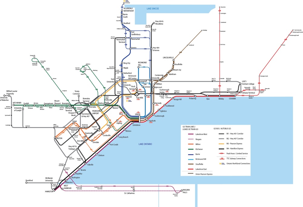
I realize that this map doesn’t solve for the ‘last mile’ problem, but many of the bus stops on this map have connections with local municipal transit services (eg. York Region Transit, Mississauga Transit etc.) so I think it will be possible in a future iteration of this map to show those connections.
Note: For those that have been following along with this project from my past blogs, here is a summary of the changes I made in this map:
- Added GO train bus replacements
- I used the same route numbering system and line thickness for the GO train bus replacements as I did for the intercity routes as it seemed more important to distinguish these routes from the more frequent, core Suburban Connectors than between each other; and
- GO train bus replacement routes that had a significant number of branches (eg. Route 21 had 18 branches) were aggregated into a smaller number of routes based on minimizing the number of stops on each aggregated route and the amount of time/length the route spent on local roads versus the 400 series highways.
- Converted the M1 between U. of Guelph to Brampton Terminal into a GO train bus replacement route, due to the frequency of Routes 31 and 33.
- Added Route 60’s seasonal service to Canada’s Wonderland and the recently announced service between Brantford and Aldershot.
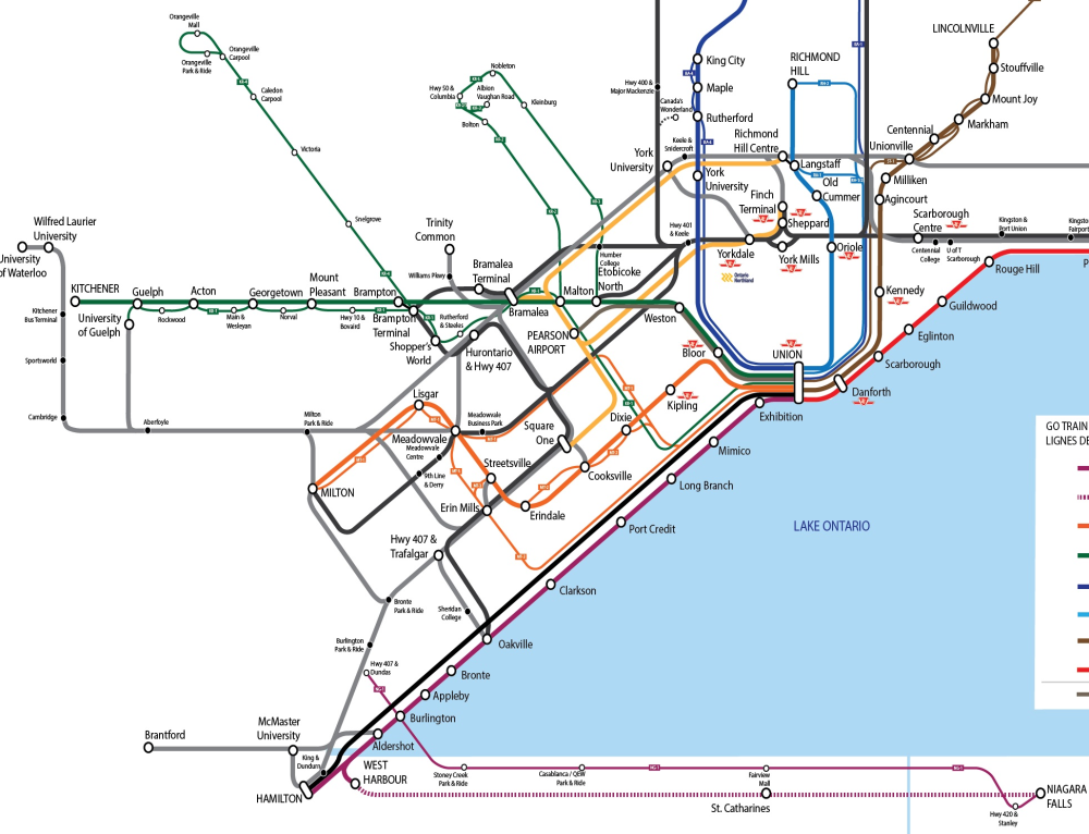
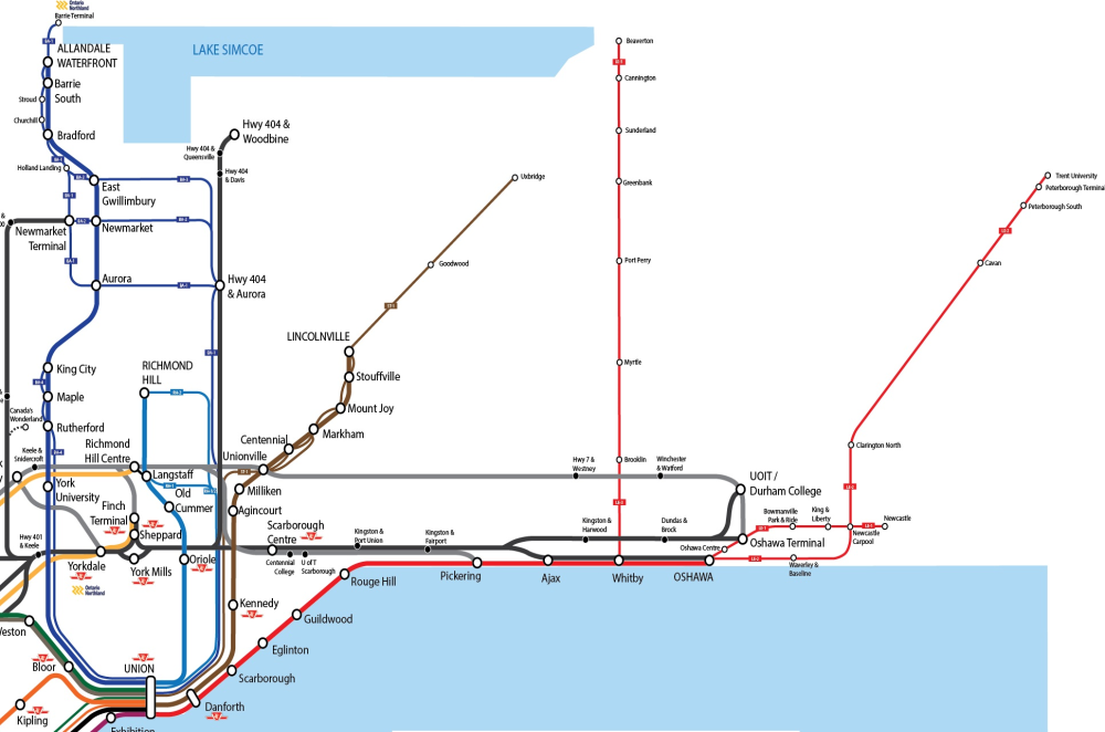
In order to see the map in more detail – I’ve included the west and east sections of the map separately below:

You are missing the seasonal only route 11. St Carharines to Niagara on The Lake.
LikeLike
Ooh – is this new? I didn’t see that route when I was making this map in January!
LikeLike
It’s been around for a few years now. Not sure when it started but even GO does not show it on their map
LikeLike